Home
Services
Projects
About Us
Connect with Us
info@pfepl.com
+91 90290 60824
Headquarters
B2 508/509, Boomerang, Off. Chandivali Farm Road,
Chandivali, Andheri East, Mumbai, Maharashtra - 400072
Connect to Content
Add layers or components to infinitely loop on your page.

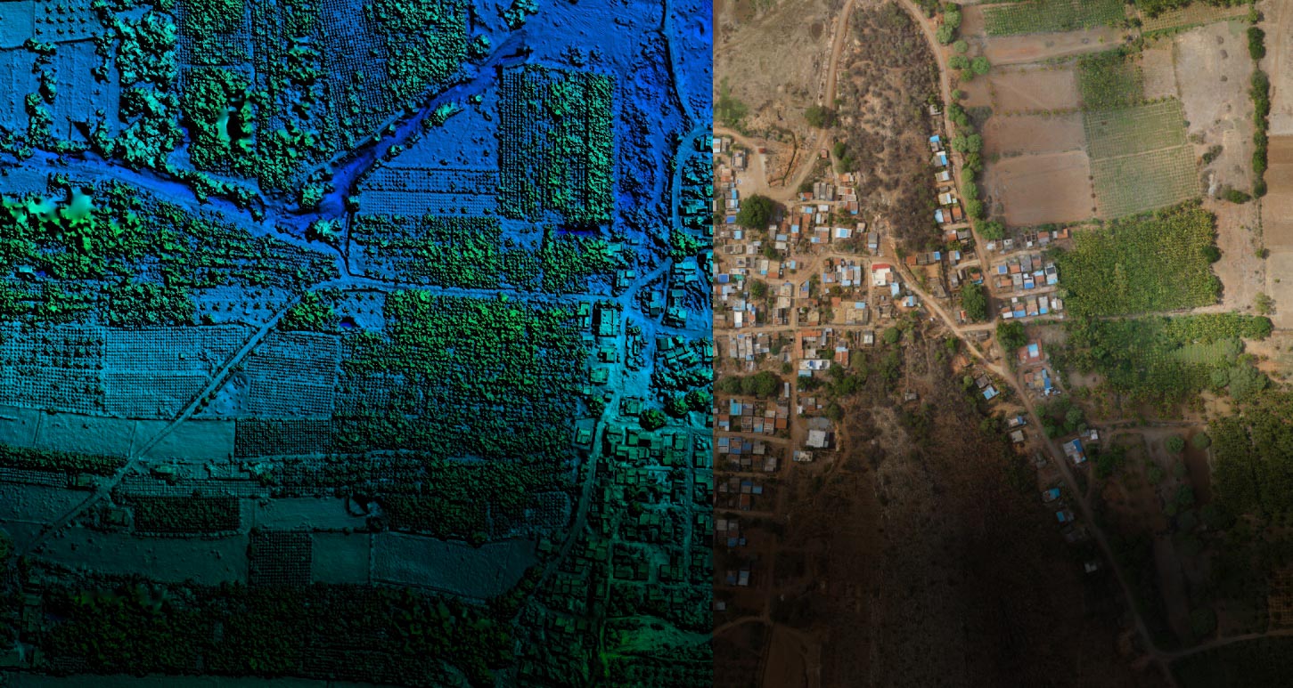
Survey, GIS & Geotechnical Investigational Services
Survey, GIS & Geotechnical Investigational Services
We provide expert Survey, GIS, and Geotechnical Investigation services using advanced technology for precise data collection. Our solutions include topographic surveys, drone-based mapping, and UAV monitoring.
We provide expert Survey, GIS, and Geotechnical Investigation services using advanced technology for precise data collection. Our solutions include topographic surveys, drone-based mapping, and UAV monitoring.
We also specialize in land parcel mapping, cadastral surveys, railroad alignment, bathymetric surveys, and boundary demarcation with control point setup for aerial mapping.
We also specialize in land parcel mapping, cadastral surveys, railroad alignment, bathymetric surveys, and boundary demarcation with control point setup for aerial mapping.
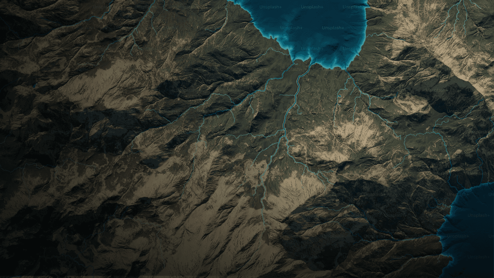
Survey, GIS Mapping Solutions
Survey, GIS Mapping Solutions
These solutions provide accurate spatial data for land, infrastructure, and environmental planning using drones, UAVs, and topographic surveys.
These solutions provide accurate spatial data for land, infrastructure, and environmental planning using drones, UAVs, and topographic surveys.

Topographic Surveys
3D GIS Mapping
Drapery Systems

Aerial & Drone-based Mapping

Remote Sensing Solutions
Geospatial Data Analysis
Topographic Surveys
3D GIS Mapping
Drapery Systems
Aerial & Drone-based Mapping
Remote Sensing Solutions
Geospatial Data Analysis
Topographic Surveys
3D GIS Mapping
Drapery Systems
Aerial & Drone-based Mapping
Remote Sensing Solutions
Geospatial Data Analysis
Topographic Surveys
3D GIS Mapping
Drapery Systems
Aerial & Drone-based Mapping
Remote Sensing Solutions
Geospatial Data Analysis
Topographic Surveys
3D GIS Mapping
Drapery Systems
Aerial & Drone-based Mapping
Remote Sensing Solutions
Geospatial Data Analysis
Topographic Surveys
3D GIS Mapping
Drapery Systems
Aerial & Drone-based Mapping
Remote Sensing Solutions
Geospatial Data Analysis
Topographic Surveys
3D GIS Mapping
Drapery Systems
Aerial & Drone-based Mapping
Remote Sensing Solutions
Geospatial Data Analysis
Topographic Surveys
3D GIS Mapping
Drapery Systems
Aerial & Drone-based Mapping
Remote Sensing Solutions
Geospatial Data Analysis
Topographic Surveys
3D GIS Mapping
Drapery Systems
Aerial & Drone-based Mapping
Remote Sensing Solutions
Geospatial Data Analysis
Topographic Surveys
3D GIS Mapping
Drapery Systems
Aerial & Drone-based Mapping
Remote Sensing Solutions
Geospatial Data Analysis
Topographic Surveys
3D GIS Mapping
Drapery Systems
Aerial & Drone-based Mapping
Remote Sensing Solutions
Geospatial Data Analysis
Topographic Surveys
3D GIS Mapping
Drapery Systems
Aerial & Drone-based Mapping
Remote Sensing Solutions
Geospatial Data Analysis
Turnkey Enterprise GIS Solutions
Turnkey Enterprise GIS Solutions
Comprehensive GIS solutions designed for seamless integration, data management, and spatial analysis, enabling efficient decision-making for enterprises.
Comprehensive GIS solutions designed for seamless integration, data management, and spatial analysis, enabling efficient decision-making for enterprises.

Custom GIS Platforms Development

Data Integration Services

Enterprise-Level Data Management

Real-time GIS Applications
Custom GIS Platforms Development
Data Integration Services
Enterprise-Level Data Management
Real-time GIS Applications
Custom GIS Platforms Development
Data Integration Services
Enterprise-Level Data Management
Real-time GIS Applications
Custom GIS Platforms Development
Data Integration Services
Enterprise-Level Data Management
Real-time GIS Applications
Custom GIS Platforms Development
Data Integration Services
Enterprise-Level Data Management
Real-time GIS Applications
Custom GIS Platforms Development
Data Integration Services
Enterprise-Level Data Management
Real-time GIS Applications
Custom GIS Platforms Development
Data Integration Services
Enterprise-Level Data Management
Real-time GIS Applications
Custom GIS Platforms Development
Data Integration Services
Enterprise-Level Data Management
Real-time GIS Applications
Custom GIS Platforms Development
Data Integration Services
Enterprise-Level Data Management
Real-time GIS Applications
Custom GIS Platforms Development
Data Integration Services
Enterprise-Level Data Management
Real-time GIS Applications
Custom GIS Platforms Development
Data Integration Services
Enterprise-Level Data Management
Real-time GIS Applications
Custom GIS Platforms Development
Data Integration Services
Enterprise-Level Data Management
Real-time GIS Applications
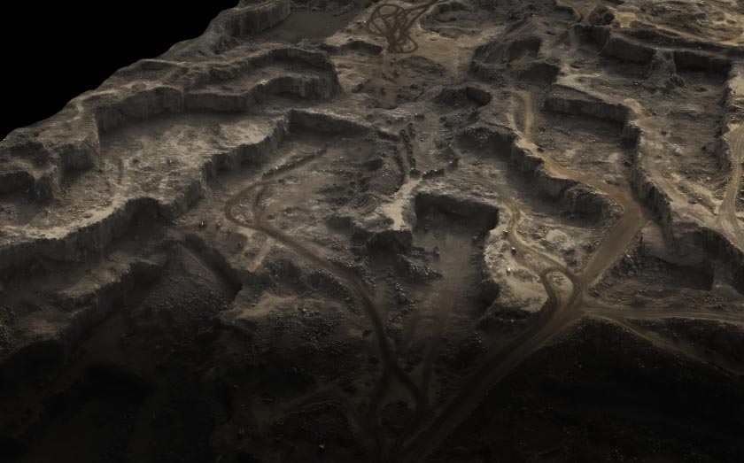
Geotechnical Investigation & Subsoil Exploration
Geotechnical Investigation & Subsoil Exploration
These processes assess soil, rock, and groundwater conditions to ensure safe and stable foundation design for construction and infrastructure projects.
These processes assess soil, rock, and groundwater conditions to ensure safe and stable foundation design for construction and infrastructure projects.

Onshore & Offshore Drilling For Geotechnical Investigation

Subsoil Investigation & Foundation Engineering

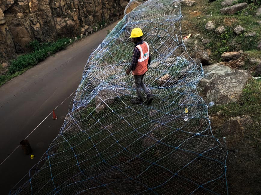
Geological Study, Slope Stability, Rockfall Assessment
Onshore & Offshore Drilling For Geotechnical Investigation
Subsoil Investigation & Foundation Engineering
Geological Study, Slope Stability, Rockfall Assessment
Onshore & Offshore Drilling For Geotechnical Investigation
Subsoil Investigation & Foundation Engineering
Geological Study, Slope Stability, Rockfall Assessment
Onshore & Offshore Drilling For Geotechnical Investigation
Subsoil Investigation & Foundation Engineering
Geological Study, Slope Stability, Rockfall Assessment
Onshore & Offshore Drilling For Geotechnical Investigation
Subsoil Investigation & Foundation Engineering
Geological Study, Slope Stability, Rockfall Assessment
Onshore & Offshore Drilling For Geotechnical Investigation
Subsoil Investigation & Foundation Engineering
Geological Study, Slope Stability, Rockfall Assessment
Onshore & Offshore Drilling For Geotechnical Investigation
Subsoil Investigation & Foundation Engineering
Geological Study, Slope Stability, Rockfall Assessment
Onshore & Offshore Drilling For Geotechnical Investigation
Subsoil Investigation & Foundation Engineering
Geological Study, Slope Stability, Rockfall Assessment
Onshore & Offshore Drilling For Geotechnical Investigation
Subsoil Investigation & Foundation Engineering
Geological Study, Slope Stability, Rockfall Assessment
Onshore & Offshore Drilling For Geotechnical Investigation
Subsoil Investigation & Foundation Engineering
Geological Study, Slope Stability, Rockfall Assessment
Onshore & Offshore Drilling For Geotechnical Investigation
Subsoil Investigation & Foundation Engineering
Geological Study, Slope Stability, Rockfall Assessment
Onshore & Offshore Drilling For Geotechnical Investigation
Subsoil Investigation & Foundation Engineering
Geological Study, Slope Stability, Rockfall Assessment
info@pfepl.com
022 48011311
Headquarters
B2 508/509, Boomerang, Off. Chandivali Farm Road,
Chandivali, Andheri East, Mumbai, Maharashtra - 400072
info@pfepl.com
022 48011311
Headquarters
B2 508/509, Boomerang, Off. Chandivali Farm Road,Chandivali, Andheri East, Mumbai, Maharashtra - 400072
info@pfepl.com
022 48011311
Headquarters
B2 508/509, Boomerang, Off. Chandivali Farm Road,
Chandivali, Andheri East, Mumbai, Maharashtra - 400072